What Is Mt Myoko? The Volcano, Its Sacred History and Climbing Safety
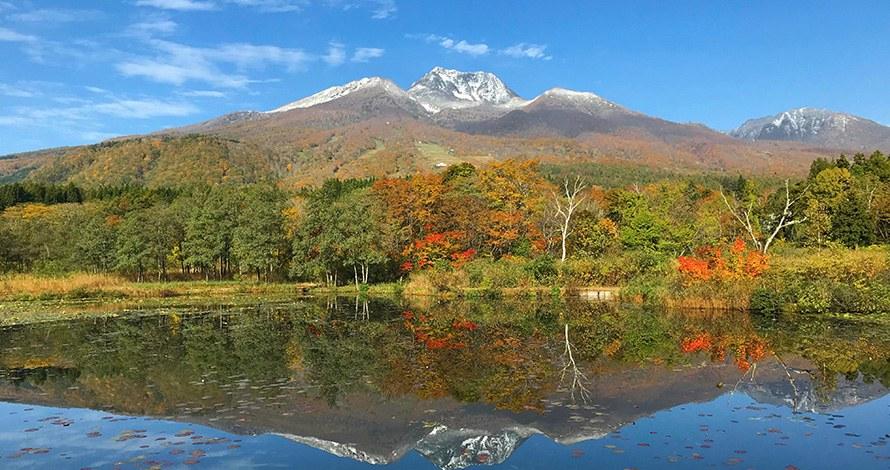
At 2,454 m, Mt Myoko is the high peak behind the ski slopes and onsen villages of Myoko. Its reflection in Imori Pond is one of the area's best-known photo spots. This guide explains what kind of mountain it is and why it is still listed as an active volcano. It also covers its long history as a sacred peak, and what official bodies ask of climbers. It is for owners and visitors who see the mountain every day and want to know more about it.
Everything below comes from Myoko City, the Japan Meteorological Agency (JMA), the Ministry of the Environment, the Japan Tourism Agency, the Myoko Tourism Bureau and the Niigata Prefectural Police, all read on 12 November 2026. Trail conditions change every season, so check official notices before you climb. This is general information only. Your safety in the mountains is your own responsibility.
The mountain in brief
- Height: 2,454 m, according to both Myoko City and the JMA.
- Status: it is one of Japan's "100 Famous Mountains" (Nihon Hyakumeizan), a well-known list of Japanese peaks.
- Setting: it stands inside Myoko-Togakushi Renzan National Park. The Ministry of the Environment says Mt Myoko, Mt Hiuchi and Mt Yakeyama are together called the Kubiki Sanzan, the three peaks of Kubiki.
- Shape: the Ministry says its striking outline comes from a central cone at the summit, surrounded by an outer rim of peaks.
How the volcano formed
The JMA describes Mt Myoko as a stratovolcano that began to form about 300,000 years ago. It grew in four periods of activity, with long quiet breaks between them.
The Japan Tourism Agency tells the more recent part of the story. Around 40,000 years ago the mountain was a cone like Mt Fuji, with its top between 2,700 and 3,000 m high. Around 20,000 years ago, steam explosions shattered the top and the centre collapsed, leaving a horseshoe-shaped caldera. Peaks such as Mt Akakura and Mt Mae are part of the rim of that caldera.
The JMA says the caldera is about 3 km across. Later eruptions built a lava dome inside it, and that dome is the summit you see today.
Is Mt Myoko still active?
Yes, it is on the JMA's list of active volcanoes, but it has been quiet for a very long time:
- The JMA says the latest eruption of magma was about 4,200 years ago. Pyroclastic flows from that period reached the foot of the mountain.
- The latest eruption that left deposits was a steam explosion about 3,000 years ago. Small explosion craters inside the caldera may be younger than that.
- There is no recorded volcanic activity in written history.
- There is an area of steam vents, called Jigokudani, on the crater floor on the south side. The Japan Tourism Agency also notes that the mountain gives off volcanic gas.
The JMA started issuing eruption forecasts and warnings for Mt Myoko on 1 December 2007. Since then the level has been the lowest one, an eruption forecast that says "be aware that this is an active volcano". On 12 November 2026 the JMA page still showed this level and said activity was calm, with no signs of an eruption that would affect the area around the crater.
Even at this level, the JMA warns that steam and volcanic gas can come out inside craters, and that entering those areas can be deadly. Volcanic gas can also collect in hollows and valleys. If you are hiking, stay on the trail and away from steam vents.
A sacred mountain
The Ministry of the Environment says Mt Myoko has long been worshipped as a sacred mountain and was a training ground for mountain ascetics. Myoko City gives more detail:
- Until the end of the Edo period, a small Buddhist hall stood on the summit. Inside was a statue group of Amida Buddha with two attendants, made to look like the main image of Zenkoji, the famous temple in Nagano. It was called "Myoko-san Nyorai".
- Once a year, on the 23rd day of the sixth month of the old lunar calendar, people climbed the mountain on a pilgrimage to the summit.
- Under the Meiji government's policy of separating Shinto and Buddhism, the statues were removed from the mountain. They are now kept in the Myoko-do hall, built next to Sekiyama Shrine at the foot of the mountain.
Watch the mountain in spring. Myoko City says that from late May to early June, snow left near the summit forms the shape of the kanji character for "mountain". The Japan Tourism Agency says this appears on the north-east face, and that people saw it as a sign of Amida and his two attendants.
Getting up high without climbing
The Myoko Tourism Bureau says the Myoko Kogen Sky Cable takes you to about 1,300 m in an 11-minute ride, with views as far as Lake Nojiri. It adds that the cable car is useful for climbing Mt Myoko. The Japan Tourism Agency notes that on cloudy days the cable car can sometimes rise above the clouds into sunshine.
The climb itself is a real mountain walk. A Myoko City video follows the trail on the upper part of the mountain, from Tengudo at 1,930 m to the summit.
The season is short
Snow comes early at this height. The Myoko Tourism Bureau reported this season's first snow on the summit of Mt Myoko on 29 October. Its autumn page also says the Koyaike hut, a mountain hut near Mt Hiuchi, closed for the 2026 season on 25 October. Prefectural Road 39 to Sasagamine was closed for the winter from 2 pm on 6 November.
Outside the snow-free months you need winter mountain skills and equipment.
The voluntary entry fee
Myoko City asks climbers in the Mt Myoko and Mt Hiuchi area for an entry fee of 500 yen per person. Paying is voluntary. The city says the money is used to protect the natural environment.
Since 7 October 2024 you can also pay the fee together with mountain insurance. The insurance covers 7 days and costs 580 yen, so the total is 1,080 yen. You apply in advance on the YAMAP website or app. You can still collect the small wooden strap, the thank-you gift, at the trailhead.
File a climbing plan
The Niigata Prefectural Police say a climbing plan is the first step in preventing accidents, and a chance to check your own plan. They ask climbers to:
- send the plan about a week before the climb;
- use the internet or an app where possible (the police list YAMAP and Compass), or send it by email, post or fax;
- tell family or workmates where they are going and when.
Our guide to hiking in Myoko, linked below, explains the plan and Niigata's mountain accident numbers in more detail.
What we could not verify, and therefore left out
- The current state of each trail on Mt Myoko, including the Akakura and Tsubame routes.
- Official opening and closing dates for the climbing season.
- Walking times for each route to the summit.
- The Sky Cable's operating season and fares.
- Which trailheads collect the entry fee in person, and when.
Related guides
- Hiking and Backcountry in Myoko: Climbing Plans and Niigata's Accident Numbers
- Mt Hiuchi, the Koyaike Hut and Japan's Northernmost Rock Ptarmigan
More from the Journal
Browse every guide in the Myoko Kogen Journal. Our articles are general information only; check official sources before you travel or climb.
Sources
All URLs retrieved 2026-11-12.
- Myoko City — 日本の宝妙高へ「妙高山登山道」 (Mt Myoko trail video, Tengudo to the summit): https://www.city.myoko.niigata.jp/docs/255.html
- Myoko City — 妙高山と善光寺 (Mt Myoko and Zenkoji: the summit hall, pilgrimage and snow shape): https://www.city.myoko.niigata.jp/docs/6709.html
- Japan Meteorological Agency — 妙高山 Myokosan (overview and eruption history): https://www.data.jma.go.jp/vois/data/tokyo/308_Myokosan/308_index.html
- Japan Meteorological Agency — 火山活動の状況(妙高山) (current eruption forecast and warnings): https://www.data.jma.go.jp/vois/data/report/activity_info/308.html
- Ministry of the Environment — 妙高戸隠連山国立公園 見どころ (Mt Myoko; Kubiki Sanzan): https://www.env.go.jp/nature/nationalparks/list/myoko-togakushi-renzan/spot/
- Japan Tourism Agency multilingual commentary database — A Wealth of Mountains: https://www.mlit.go.jp/tagengo-db/en/R3-00320.html
- Japan Tourism Agency multilingual commentary database — Life in the Mountains: https://www.mlit.go.jp/tagengo-db/en/R3-00324.html
- Myoko Tourism Bureau — 妙高高原スカイケーブル (Myoko Kogen Sky Cable): https://myokotourism.jp/tourist-spots/%E5%A6%99%E9%AB%98%E9%AB%98%E5%8E%9F%E3%82%B9%E3%82%AB%E3%82%A4%E3%82%B1%E3%83%BC%E3%83%96%E3%83%AB/
- Japan Tourism Agency multilingual commentary database — Myoko Kogen Sky Cable: https://www.mlit.go.jp/tagengo-db/en/H30-00582.html
- Myoko Tourism Bureau — autumn leaves (first snow on Mt Myoko; Koyaike hut and Sasagamine road notes): https://myokotourism.jp/autumn-leaves/
- Myoko City — 妙高山・火打山地域「登山保険付き入域料」の開始について (entry fee with mountain insurance): https://www.city.myoko.niigata.jp/docs/62881.html
- Niigata Prefectural Police — 登山計画書 (climbing plans): https://www.pref.niigata.lg.jp/site/kenkei/tozanplan.html
Header photo: “Mount Myoko with early snow, reflected in the still water of Imori Pond, with autumn trees along the shore” (Ministry of the Environment, Japan / 環境省), https://www.env.go.jp/nature/nationalparks/list/myoko-togakushi-renzan/spot/. Edited (cropped and resized) for use as the header image on this page. Used under the Public Data License (PDL) Version 1.0.
