Mt Hiuchi, the Koyaike Hut and Japan's Northernmost Rock Ptarmigan
Mt Hiuchi is one of the high peaks above Myoko, and one of Japan's 100 famous mountains. Below its summit lie high wetlands with a mountain hut listed by Myoko City, and on its upper slopes lives Japan's most northerly group of rock ptarmigan. This guide explains what is up there, how the hut works, and how to go well prepared.
Everything below comes from the Ministry of the Environment, the Japan Tourism Agency's multilingual commentary database, Myoko City and Niigata Prefectural Police, read on 6 November 2026. Mountain conditions and hut dates change, so check before every trip.
Mt Hiuchi
- Height: 2,462 metres, on the border of Itoigawa and Myoko.
- Status: one of Japan's 100 famous mountains.
- Neighbours: with Mt Myoko and Mt Yake, it forms the group called the Kubiki Three Mountains. The Ministry of the Environment says Mt Yake (2,400 m) is an active volcano that still gives off steam.
Koyaike and Tengu-no-Niwa
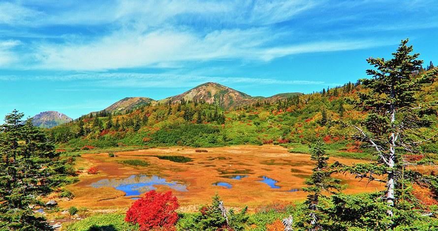
The Ministry of the Environment says that at about 2,100 metres, wide high-moor wetlands called Koyaike and Tengu-no-Niwa ("the goblin's garden") spread out below the summit. They offer flower meadows, cotton grass and autumn colour through the seasons.
The Koyaike hut
Myoko City lists the Koyaike Hutte, a mountain hut by the wetland:
- Season: mid-April to early November. The city says this may change depending on the remaining snow.
- Booking: required in advance. Bookings open on 1 April.
- Where to book: the city names Myoko Tourism Management, a general incorporated association, by phone on 0255-86-3911 (9 a.m. to 6 p.m.) or fax on 0255-86-3450.
- Prices: the city asks you to check the booking organisation's website.
The rock ptarmigan
The Japanese rock ptarmigan (raicho) is a ground-dwelling bird of the grouse family. The Japan Tourism Agency's commentary database explains why the birds on Mt Hiuchi are special:
- The species is endangered, partly because it lives only on high mountaintops whose deep snow and sparse plants resemble the ice age it evolved in.
- In Myoko-Togakushi Renzan National Park, rock ptarmigan are found only on Mt Hiuchi and neighbouring Mt Yake, a population of only several dozen birds.
- The area around Mt Hiuchi is the most northerly ptarmigan habitat in Japan.
- The birds change colour with the seasons: almost all white in winter, mottled in spring and grey in autumn.
The Ministry of the Environment adds that because the population lives at a low altitude for ptarmigan, it is easily affected by climate change, and its small numbers put it at risk of extinction.
The database says warming has let monkeys, martens, foxes and even crows climb higher to take chicks and adults, and deer and boar now eat the plants the birds rely on. Grasses from lower slopes are spreading into the alpine zone. The Ministry of the Environment and local governments are working on Mt Hiuchi to remove these grasses and to monitor predators.
Other alpine life
The database says the high peaks support low-growing plants such as Siberian dwarf pine, mountain heath and bog bilberry. Ermine also live there all year. In the warmer months, alpine butterflies and dragonflies appear.
Going well prepared
Niigata Prefectural Police ask everyone heading into the mountains to file a climbing plan about a week before the trip, and to tell family the schedule. They recommend filing through a mountain app, and also accept plans by email, post or fax. In 2025, getting lost was the most common cause of mountain accidents in Niigata, followed by slips and falls.
When you see ptarmigan, enjoy them from the trail. The database explains how much pressure the birds are already under.
What we could not verify, and therefore left out
- The usual trailhead, route and walking times to Koyaike and the summit.
- Hut prices, meals and capacity for 2026.
- Whether camping is permitted near the hut.
- Rules for visitors near ptarmigan, such as distances to keep.
- Current volcanic alert levels for Mt Yake.
Related guides
- Checking Natural Hazards Before You Buy in Myoko: Floods, Volcanoes, Quakes
- What Is Naena Falls? Myoko's 55-Metre "Earthquake Falls"
More from the Journal
Browse every guide in the Myoko Kogen Journal. This guide is general information. Check conditions and file a climbing plan before you go.
Sources
All URLs retrieved 2026-11-06.
- Ministry of the Environment — 妙高戸隠連山国立公園 見どころ (Mt Hiuchi, Koyaike and Tengu-no-Niwa, Mt Yake, rock ptarmigan): https://www.env.go.jp/nature/nationalparks/list/myoko-togakushi-renzan/spot/
- Japan Tourism Agency multilingual commentary database — 雪と水がつなぐ生きもの (R3-00321: alpine life, rock ptarmigan, conservation): https://www.mlit.go.jp/tagengo-db/R3-00321.html
- Japan Tourism Agency multilingual commentary database — 妙高戸隠連山国立公園 (R1-01527: northernmost ptarmigan habitat): https://www.mlit.go.jp/tagengo-db/R1-01527.html
- Myoko City — 高谷池ヒュッテ (season, booking): https://www.city.myoko.niigata.jp/docs/1694.html
- Niigata Prefectural Police — 登山計画書届出 (climbing plans): https://www.pref.niigata.lg.jp/site/kenkei/tozanplan.html
- Niigata Prefectural Police — 令和7年中の山岳遭難発生状況 (PDF: mountain accidents in 2025): https://www.pref.niigata.lg.jp/uploaded/attachment/512734.pdf
Header photo: “Autumn colours over the Kamikoh marshland on Mount Hiuchi, with red shrubs and small ponds” (Ministry of the Environment, Japan / 環境省), https://www.env.go.jp/nature/nationalparks/list/myoko-togakushi-renzan/spot/. Edited (cropped and resized) for use as the header image on this page. Used under the Public Data License (PDL) Version 1.0.
