What Is Naena Falls? Myoko's 55-Metre "Earthquake Falls"
Naena Falls is a sight for Myoko's green season, not its ski season. It is a 55-metre waterfall on the Seki River, right on the line between Niigata and Nagano prefectures, about 15 minutes on foot from a car park reached through the Suginosawa area of Myoko City. This guide explains what it is, where the name comes from, what the walk in is like, and when to go.
Everything below comes from the Myoko City website, the Myoko tourism board and the Ministry of the Environment's national park pages, all read on 22 September 2026. Opening seasons and road conditions change, so check the official pages before you set out.
What is Naena Falls?
Naena Falls (Naena-taki) sits where Myoko City in Niigata meets Shinano Town in Nagano. The Ministry of the Environment lists it as a sight of the Myoko-Togakushi Renzan National Park. It notes that the falls were chosen as one of Japan's Top 100 Waterfalls.
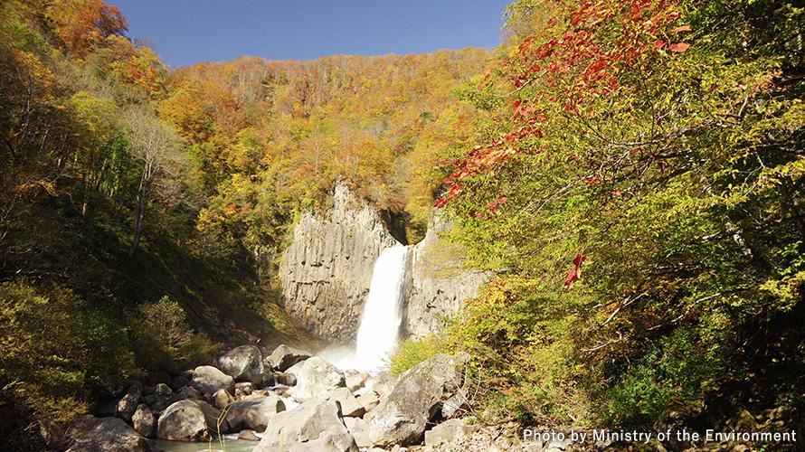
The drop is 55 metres. What makes it look different from most waterfalls is the rock around it. The walls are columnar joints: tall, many-sided pillars that form when lava cools. The water throws up spray as it plunges down between them.
A waterfall made by a volcano
Myoko City tells the story of how the falls formed. About 30,000 years ago, Mt Kurohime erupted. Andesite lava flowed out and blocked the Seki River, and a small lake formed on what is now the prefectural border. Water kept building up behind this natural dam. When it reached its highest level at the lake's western end, it spilled over, and Naena Falls was born.
The shape you see today is more recent. The city says that about 200 years ago, logging was the main industry here, and logs were floated down the river. A huge rock once sat at the top of the falls and split the water into two streams. Years of logs hitting it broke the rock apart, and by 1814 the falls had taken their current form.
Why it is called the "earthquake falls"
The name is about sound. In old Japanese, nai meant "earthquake". The city explains that people first called the falls nai because of the roar of the water hitting the rocks 55 metres below. Over time, nai became nae, and na (name) was added: "the falls called nae". The tourism board still gives its other name, Jishin-daki, which means "earthquake falls".
The tourism board adds one more piece. The characters used to write the name today include 苗 (nae), meaning rice seedlings. It says this character was chosen because the river's water feeds the rice fields of the Takada Plain downstream.
The poet who stopped here
In the Edo period, poets and travellers often wrote about the falls. The best known is the haiku poet Kobayashi Issa (1763–1828), who grew up near Kashiwabara, in what is now Shinano Town, just over the border. According to the city, Issa visited in April 1813 and wrote this:
Taki keburi / soba de mite sae / hana no kumo
Roughly: "The waterfall's mist — even seen from close by, a cloud of cherry blossom." The poem is carved on a stone near the suspension bridge on the way to the falls, so you will pass it on the walk.
How do you get to the falls?
The tourism board describes the route. In April 2016 a new road opened to the falls: a two-lane city road about 1.5 km long that runs along the Seki River. Large tour buses can use it, and it has a footpath. It starts at the Jishin-daki Bridge, which crosses the Seki River on the prefectural border in the Suginosawa area.
At the end of the road there is a large car park with room for 104 cars and 11 large vehicles, plus flush toilets. From there, the tourism board puts the walk at about 15 minutes each way.
The walk itself is part of the visit. You cross a first suspension bridge over the Seki River, and with that step you are in Nagano. Then you climb steps beside an erosion-control dam and follow a path lined with snow camellias. You pass the stone with Issa's poem. The rock walls above you are covered in ferns. A second suspension bridge takes you close to the plunge pool, and on a large rock just past it there is a small shrine to a water god.
When is the best time to go?
The tourism board lists the falls under spring, summer and autumn. In spring, snowmelt makes the flow dramatically heavier. In summer, the gorge is a cool place to be. In autumn, the leaves turn and the falls are at their most colourful. The Ministry of the Environment's page picks May as its recommended time.
Winter is not on either list. If your trip to Myoko is a ski trip, plan Naena Falls for a green-season visit instead. The header photo on this page shows the falls in autumn.
Food at the trailhead
At the start of the walking path, the tourism board points to Naenataki-en, a restaurant known for nagashi somen — thin noodles sent down a flowing water chute that you catch with chopsticks. Next door, a café serves soft-serve ice cream with toppings such as blueberries and raspberries.
Before you go: bears
This is mountain forest, and bears live here. Niigata Prefecture has had a bear warning in force since 19 May 2026, and Myoko City asks visitors to take care. Its advice for hikers and campers is simple. Watch your surroundings, walk in a group where you can, and carry something that makes noise, such as a bell or a radio. Bears are most active early in the morning and in the evening. If you see a cub, do not go near it, because the mother may be close by.
What we could not verify, and therefore left out
We did not find an official page, current on the day we checked, giving the exact dates the road and path close for winter, so we have not given any. We also have not described public transport to the falls or opening hours for the restaurant and café. Check with the Myoko Kogen tourist information centre before you go.
Related guides
More from the Journal
Browse every guide in the Myoko Kogen Journal. This guide is general information for visitors.
Sources
All URLs retrieved 2026-09-22.
- Myoko City — 苗名滝 (formation 30,000 years ago, origin of the name, 55 m, logging and the 1814 change, Kobayashi Issa's 1813 visit and haiku, the stone near the suspension bridge, location): https://www.city.myoko.niigata.jp/docs/31651.html
- Myoko Tourism Board — 苗名滝 日本の滝百選 (columnar joints, Jishin-daki, seasons, the walk, water god shrine, 苗 and the Takada Plain, 2016 road, car park, 15-minute walk, trailhead food): https://myokotourism.jp/tourist-spots/%E8%8B%97%E5%90%8D%E6%BB%9D-%EF%BC%88%E6%97%A5%E6%9C%AC%E3%81%AE%E6%BB%9D%E7%99%BE%E9%81%B8%EF%BC%89/
- Ministry of the Environment — Myoko-Togakushi Renzan National Park, sights (location on the border, Top 100 Waterfalls, columnar-jointed rock wall, recommended month May): https://www.env.go.jp/nature/nationalparks/list/myoko-togakushi-renzan/spot/
- Myoko City — クマにご注意ください (bear warning in Niigata from 19 May 2026, advice for visitors): https://www.city.myoko.niigata.jp/docs/910.html
Header photo: “Naena Falls dropping between walls of columnar rock, with autumn leaves on the slopes around it” (Ministry of the Environment, Japan / 環境省), https://www.env.go.jp/nature/nationalparks/list/myoko-togakushi-renzan/spot/. Used under the Public Data License (PDL) Version 1.0.
