What Is Sasagamine? Myoko's Highland of Springs, Spruce and Lake Otomi
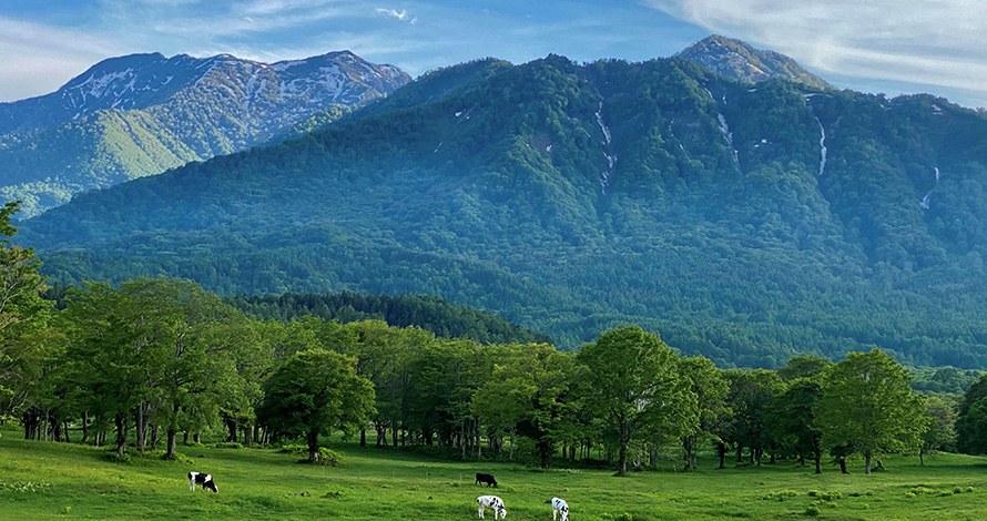
Sasagamine is a highland plateau about 1,300 metres up, surrounded by the Myoko mountains. In summer it is a cool place of beech and birch forest, a large cattle farm, a famous spring and a dammed lake. In winter it lies under more than five metres of snow. This guide explains what is there, for visitors and for owners looking for a day out in the green season.
Everything below comes from Myoko City and the Ministry of the Environment, read on 4 November 2026. Facilities open and close with the seasons, so check before you go.
The highland
- Height: around 1,300 metres, inside Myoko-Togakushi Renzan National Park.
- Climate: Myoko City says humidity is low, and temperatures can range from 28°C in summer to minus 28°C in winter, when snow can build up to more than five metres.
- Walking: the Ministry of the Environment says many walking paths have been laid out across the plateau, for trekking from spring to autumn.
Udana Spring
Udana Spring (Udana no Shimizu) is the best-known stop. Myoko City says it was found during the first clearing and development of the area, which began in 1811. The name comes from the sudden change in landscape, from steep mountains ("u", a roof) to the wide plain ("tana" or "dana", a shelf).
- It produces 4.8 million litres of water a day, filtered down from the mountains.
- The water stays at 6°C all year. Watercress grows in the streambed, a sign of its purity.
- Local people collect the water for tea, coffee and cooking.
The Ministry of the Environment notes that the spring, inside Sasagamine Farm, was chosen as one of Japan's 100 best waters of the Heisei era.
The spruce forest
Myoko City says the European spruce forest here is the largest on Honshu. Niigata Prefecture planted it in 1984 to protect local water resources. About 10,000 trees cover 60 hectares, from the farm entrance almost to the Seki River. They average about 20 metres tall. The city adds that European spruce is used for Christmas trees, and for the soundboards of violins and guitars.
The city calls the wider area the "Myoko Sanroku Prefectural Forest", about 157 hectares. Its paths through the spruce forest are recognised as a "forest therapy road".
Sasagamine Farm
- About 600 hectares of meadow with elm, beech and white birch.
- The snow melts by late May. Meadow buttercups then turn the fields yellow from spring to summer.
- In July and August, around 100 cattle graze here: Holstein dairy cows, and Japanese Black and Japanese Shorthorn beef cattle.
Lake Otomi and Sasagamine Dam
Lake Otomi lies behind Sasagamine Dam, a rock-fill dam 48.6 metres high and 318 metres long. Myoko City explains its history:
- The lake first formed more than 30,000 years ago, when a huge landslide from the top of Mt Kurohime blocked the Seki River.
- Twelve hydropower stations were built along the river between 1906 and 1939, to bring down the cost of electricity and help the region develop.
- The present dam was built between 1970 and 1979. The lake now holds 900,000 tonnes of water. It feeds power stations and irrigates 7,200 hectares of fields 50 km downstream.
From the dam, the city says you can see a line of peaks, including Mt Myoko, Mt Hiuchi and Mt Yake, an active volcano that still sometimes gives off smoke.
The Yumemidaira trail
Stairs at the far end of the dam lead up to the Yumemidaira Hiking Trail, through beech and white birch forest. Myoko City describes two courses:
- Rabbit Course (3 km, about 2 hours): passes a pond where frogs and Japanese black salamanders lay eggs every June. It then follows an old rail bed, once used by horse-drawn carts to carry timber 20 km to what is now Kurohime Station. Skunk cabbage and dogtooth violets flower in spring. There is a small Inari shrine, found in 1991 and thought to date from the Edo period.
- Fox Course (10 km, about 4.5 hours): starts through Japanese larch groves. It passes the site of a lumber mill that ran for about 20 years from 1932, whose village even had a primary school. A side path to a 300-year-old katsura tree adds about an hour.
The city notes that toilets are only at the start of the Rabbit Course and along the Fox Course.
Eating and staying
The prefectural forest has two facilities: the Sasagamine Green House, which serves meals, and the Mori no Manabiya, which offers accommodation. The city says they may close temporarily, and publishes their opening status.
Wildlife and safety
Sasagamine is a forest area. Before walking the trails, read our guide to official bear alerts in Myoko, linked under Related guides below.
What we could not verify, and therefore left out
- The opening dates of the Green House and Mori no Manabiya for 2026.
- When the road to Sasagamine opens and closes for the winter.
- Bus access to Sasagamine.
- Parking and any fees.
- Whether drinking the spring water is officially recommended.
- Myoko City advice on wild animals at Sasagamine. The page we used in October is no longer online, so we left that advice out.
Related guides
- What Is Naena Falls? Myoko's 55-Metre "Earthquake Falls"
- Bears in Myoko: Official Alerts and What They Mean for a Holiday Home
More from the Journal
Browse every guide in the Myoko Kogen Journal.
Sources
All URLs retrieved 2026-11-04.
- Myoko City — Prefectural Forest (English: Udana Spring, spruce forest, Sasagamine Farm, climate): https://www.city.myoko.niigata.jp/docs/31656.html
- Myoko City — Sasagamine Dam "Lake Otomi", Yumemidaira Hiking Trail (English): https://www.city.myoko.niigata.jp/docs/31660.html
- Myoko City — 笹ヶ峰グリーンハウス・森の学び舎に遊びにきませんか? (prefectural forest, facilities, forest therapy road): https://www.city.myoko.niigata.jp/docs/83517.html
- Ministry of the Environment — 妙高戸隠連山国立公園 見どころ (Sasagamine Highland, Mt Hiuchi, Mt Yake): https://www.env.go.jp/nature/nationalparks/list/myoko-togakushi-renzan/spot/
Header photo: “Cattle grazing on the green Sasagamine highland with forested mountains behind” (Ministry of the Environment, Japan / 環境省), https://www.env.go.jp/nature/nationalparks/list/myoko-togakushi-renzan/spot/. Edited (cropped and resized) for use as the header image on this page. Used under the Public Data License (PDL) Version 1.0.
